Mount Cargill, Dunedin


Two posts in two days, I’m on a roll! The post will detail our hike up to the summit of Mount Cargill and the detour we did to the Organ Pipes. This has been a walk I’ve wanted to do ever since I moved to Dunedin. From our bedroom window we can see the towering summit of Cargill (granted you have to crane your neck to see it), and it is the biggest component of the Dunedin skyline.

I will start this post by talking about an extraordinary individual named Alfred Hamish Reed. Born in England in 1875, he moved to Dunedin at a young age and worked on gum fields with his family and for some time lived many hardships. When he was a child he injured his knee so severely that he was bed-bound for one year. In his very little spare time he took up the skill of shorthand, and eventually got a job with a typewriter company. In his early 20s he moved to Dunedin to open a branch of the company. From there he established his own publishing company which went on to be hugely successful. He wrote many books about New Zealand and published many religious texts. Due to this, he is regarded as one of the most influential literary figures of New Zealand in the twentieth century. Now, you may be wondering why I am telling you this. Alfred wasn’t just a writer, but he was also an avid walker. Even with all his knee trouble, he still rambled frequently into his ripe old age. At the age of 99, Alfred climbed Mount Cargill. There is meant to be a short track on the Mount dedicated to this remarkable man, but we could not find it.

untitled.png

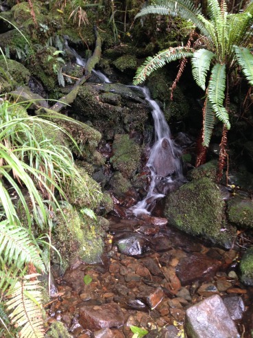
Our walk began in Bethune’s Gully which is a great spot near north Dunedin. It has the appearance of a place far from a city centre, and would have been a great place for a BBQ. As you embark on the track you are quickly consumed by the New Zealand Bush. Although there is incline the whole way there, it is a fairly easy going track for the first hour, and the creeks and greenery around you make for a scenic walk. As you start to rise higher all you can see is bush, and much of the track feels like an earthy tunnel. You can see the odd glimpse of the sky, but the summit cannot be seen for most of the walk.

file-1

After an hour you reach the open air and find the steps up to the summit. These can be slippery, but make it much easier to climb than on the mud. Although Mount Cargill is only a mere 676 meters high, it did have the feel of walking on a mountain towards the end.

file1-1

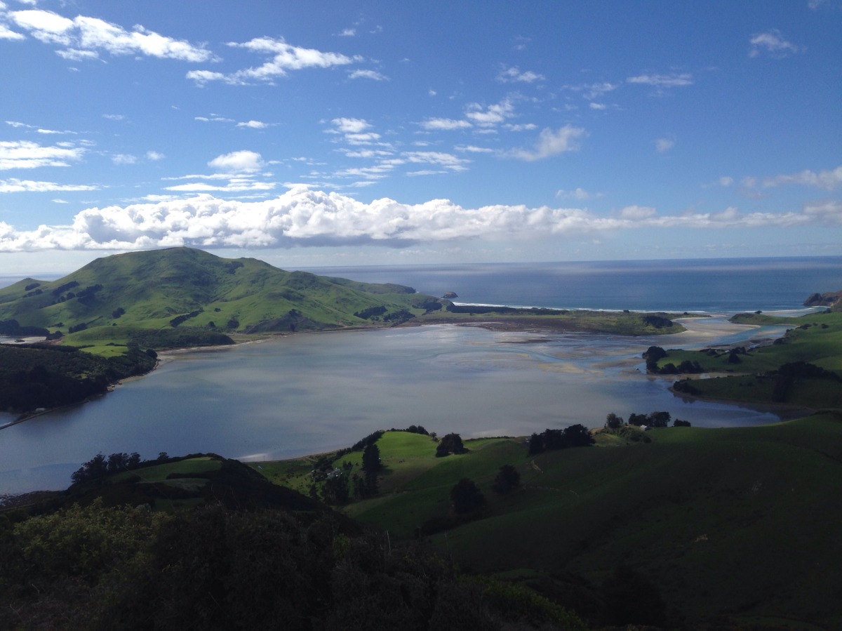
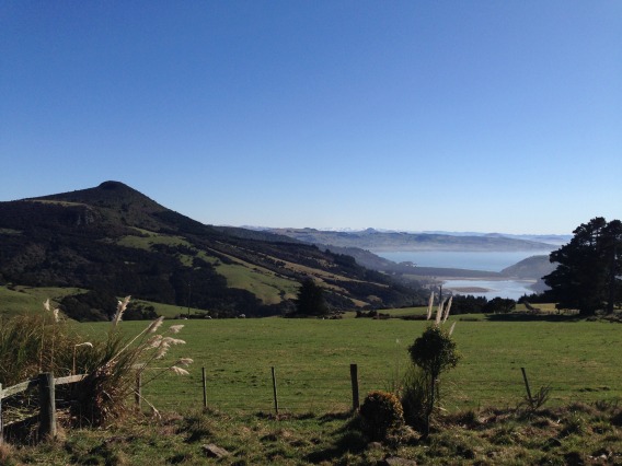
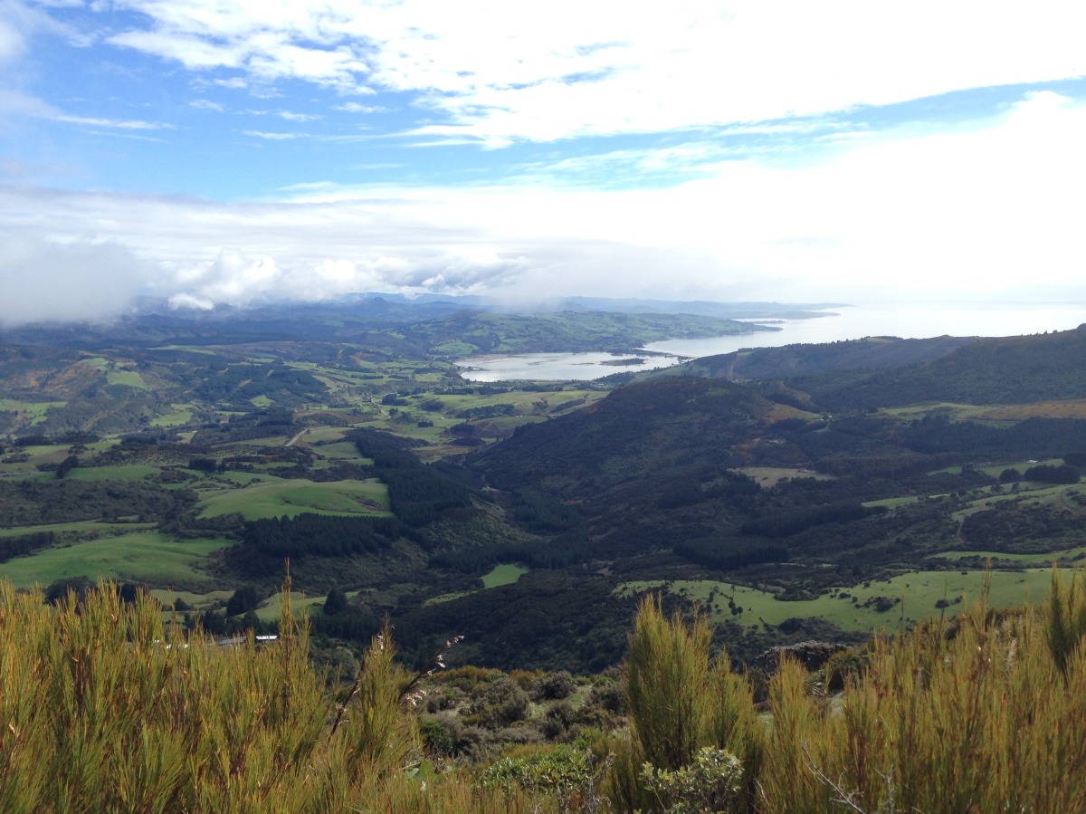
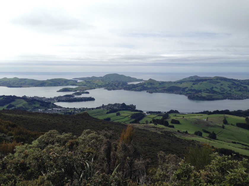
Once you reach the top and see the views, I guarantee your jaw will come crashing down to the floor. It. is. incredible. I have seen so many different variations of this scene, and the theory holds true, the higher you go, the better the view. The Peninsula slithers through the land, the hills slalom in-and-out around it, the city sleeps ever-still, and the clouds and land assemble together in a triumphant transition. This is Dunedin’s best view, and one can understand why the aged Alfred Hamish Reed grappled with Cargill to see it.

file-2.jpeg

file1-2.jpeg

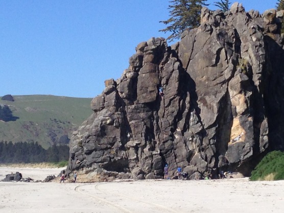
On our way back we decided to take the detour to the Organ Pipes. It was a 30 minute walk to the other side of the Mount, and the way down was fairly slippery due to the recent rain. The Organ Pipes are a geological formation, from lava that cooled, contracted, and formed cracks which propagated downwards as the mass cooled. While you can clearly see why it is called such from sight, the pictures I got were not as clear. Therefore, I decided to climb up them as high as I could go. This was to my girlfriends dismay as she thought it ‘was too dangerous.’ If you’re an able climber I would advise to do it. There was an abundance of foot-holes, and it was very fun. I had played a few games in the Tomb Raider series when I was younger, and I felt just like Lara descending an ancient temple. I climbed fairly high and managed to get a few better pictures of the Organ Pipes and descended back down.

The whole hike was around 5 hours in total, with the way up to the summit, the detour to the Organ Pipes, and the way back down.  To say the weather in Dunedin has been pretty miserable lately, this was a walk to brighten up the gloom. I hope that if I get to the age of 99 I can still hike as well as Alfred Hamish Reed, and if I can I’ll certainly return to do this walk.

Harbour Cone, Otago Peninsula

It’s been a while since I have properly posted anything, but I’ve been a busy, busy bee. I do however have plenty of exciting walks to share with you. The most recent was on Harbour Cone. If you’ve read my posts before you’ll probably know that I’m an Otago Peninsula fanatic. I’m considering staring a fan club. Harbour Cone was brought to my attention while looking around the Dunedin Public Art Gallery. There I saw this very cool painting below, which detailed that it was the largest hill on the Peninsula. So the next day, when it wasn’t siling it down with rain, we embarked to the OP and set off walking over the rolling hills.

untitled

(Robin White, Harbour Cone)

There were several different approaches you could go to on the hike, and we chose the one starting from Broad Bay. From there, we were given the choice of the left-hand Bacon St track, or continue right on the Highcliffe Rd track. We chose the latter after a local advised us it was a less arduous, but longer route, offering better views on the way. The first half of the walk was a beautiful country stroll through farmers fields. You are surrounded by sheep, lush green hills, and the odd glimpse of the ocean. Some of the crossings were fairly overgrown, which meant you had to cross over the main road a few times, but it was always clear which direction the route was meant to go.

image-2

After about an hour you reach the bottom of a steep track up to the summit of Harbour Cone. This proved challenging but a lot of fun. The Bacon Rd track which we decided against was meant to have been like that for the entire walk. I think here we definitely chose wisely.

image-1

As we made our way up we turned away from the hill every so often to see a more spectacular view each time. Once we had reached the top we were greeted with a stunning 360 panoramic of the Dunedin harbour, the peninsula, Hoopers Inlet, and many of the different beaches I have written about before. If we hadn’t hiked up to Mount Cargill the previous week, I would have said that it was the best view Dunedin has to offer. It is stunning. To me, the picture below has the appearance of an oil painting, and my memory of it is very similar. Hoopers Inlet, which is the body of water in the centre of the picture, looks rather boggy driving next to it. From above it is incredible. The beach to the right of the image is Allan’s.

Image.png

Harbour Cone is a fantastic walk that I would recommend to anyone in the area. Much of it is easy-going, and the last stint is fairly difficult, but the views along the way and at the top are well worth it. For anyone wanting to join the Otago Peninsula Fan Club, henceforth known as OPFC, drop me a message. T-shirts for all its members! (members must purchase there own T-shirts)

(I will write about our Mount Cargill hike and Wanaka Part 2 very soon I promise)

Long Beach, Dunedin (Part 1)

Lying just 30 minutes drive outside of Dunedin, Long Beach is one of the most popular beaches in the area, and it is easy to see why. The journey there, the beach, the cliffs, and the caves, all make this place simply stunning.

Warauwerawera, as Long Beach is known in Maori, is a small settlement just past Port Chalmers, with around 100 homes. Due to the fact that the beach lies in a bay and is not very affected by swells, it is a very popular swimming destination. But to look at this place you would want to swim here even if the waves were higher than your head. It is a paradise. It is also popular due to the rock faces which offer great climbing opportunities. There are many clubs that use the cliffs in the area. The most favoured is called Driver’s Rock, which lies halfway along the north end of the beach. The rock got its name after a fourteen year old girl named Agnes Driver died there in 1890. People believe that Agnes was walking along the cliffs with her sister and a gust of wind blew her hat onto a tree near the cliffs edge. She supposedly then lost her footing when reaching for her hat and fell from the edge.

file6.jpeg

Now, you may have been wondering why this post is called ‘Part 1.’ This is because we were strapped for time when we first came here and did not get to see the place to its full potential. In this post I will talk further on the journey to Long Beach, and the cliffs and beach itself, but we did not have the chance to explore the vast caves. I was under the impression that they were rather small but large enough to camp in. However, after talking to a friend about them he had explained that they go very far back and one would need a torch to see it all. I will report further on these when I return to them, which will be in the not too distant future.

The journey to Long Beach was fantastic, and this was due to the landscape. A perk of living in New Zealand is that the scenery on the way to your destination is nearly always as beautiful as the place you end up. We couldn’t believe that we had not seen these views before. They were amazing. I don’t usually like car journeys, as I tend to get some mild travel sickness, but when travelling around here you seem to forget about your ailments and just drink in the country.

file1 (2).jpeg


file2-2

Long Beach itself is a scenic paradise. The cliffs surrounding the settlement very much remind me of Austria and that is a wonderful thing. It didn’t seem very much like New Zealand to me at all, but the landscape does seem to be ever changing, and I guess I haven’t seen all that much of this place just yet. Going to places like this really make you think you are on holiday. As I mentioned earlier, the cliffs are a popular place for rock climbers, and we managed to catch a glimpse of them. We both would love to have a go at it properly with harnesses, so maybe when I come back to finish ‘Part 2’ you may see some pictures of me half way up the cliffs edge (hopefully not crying out of fear).

file7.jpeg


The beach itself is one of the best we have been to. Looking out to the ocean from it is mesmerising. There is not a thing in sight. No boats, no surfers, no nothing. It is not likely to be the same in the height of summer, but it was great to have it all to yourself. I can confirm too that the beach is ‘Long’ and offers a picturesque walk of around 2.4km. With the cliffs, the ocean, and the openness of the beach, it makes for great scenery as you leisurely stroll.

file5.jpeg

All in all I must say that this beach has a lot to offer. I was annoyed that we didn’t get to see everything the first time but we will definitely be going back to check out more. The cliffs, caves, rock-climbing, and beach are fantastic features of this small scenic settlement, and I cannot wait to update you with ‘Part 2.’

Brighton Beach, Dunedin

Okay, I’ll admit that this isn’t as much a beach review as it is advice on how to spend a jolly good Saturday morning. We just happened to choose Brighton Beach which turned out to be an excellent setting.

We started our day early by going to the bustling Dunedin Farmers Market. This is a place we’ve frequented regularly on our Saturday mornings, as it is a great chance to pick up some regional fruit, veg, and what we love most, cheese & bread. We decided on a loaf of Focaccia, and four different segments of cheeses. The market sells fantastic products, and there are usually a few guitar, violin, or piano players around, which adds to the vibrant atmosphere.

aaa

Once we had made our purchases we wandered home to pick up supplies and set off to Brighton Beach, which lies about 20 kilometres south west of Dunedin. The beach is long, but doesn’t have as many of the cool features I have come across at other New Zealand beaches. That should not deter you though, as it makes for a great walk, run or picnic. It is a fairly popular destination, but in typical New Zealand fashion it was pretty deserted barring a few families, and so we set up our extravagant picnic in the perfect isolated spot. The views were wonderful, and the whole scene made for a relaxing lunch. All we needed was a bottle of Speight’s Golden Ale to bring it all together, but we settled for a nice cup of tea instead. We’ve become exceedingly British in the fact that we take a flask with tea in everywhere we go now. We probably keep it over water on most trips. On this occasion we took our cups with us while we went for a paddle. Not noticing the tide coming in rapidly we turned to find it was upon us and a large wave showered us. You’ll be pleased to hear our cups of tea made it out alive, much to our relief. Take our clothes but never take our tea.

14397214_1765222777065933_1572864599_n


Our Saturday morning was well spent at a great beach and with great food. While I would encourage you to check out Brighton Beach, the more important message would be to get out and enjoy yourself outside. It’s been a long time since I’d had a picnic and if you are the same, get to the market, get your tupperware out and head to the beach. This is probably easier done than said for those in New Zealand, but everyone should do it. I may be preaching to the choir here with travel bloggers, but it’s called the great outdoors for a reason, right?


Victory Beach, Otago Peninsula

Not only is this the longest beach on the Otago Peninsula, it is also one of the best. At 3.5km, it offers the chance for a great afternoon ramble, a picnic, and even the opportunity to climb The Great (little) Pyramid.

Around 30 minutes drive from the Dunedin City Centre, Victory Beach is situated on the Pacific Ocean coast of the Peninsula. If you’ve read any of my blog posts before you will probably know that I write about the Otago Peninsula quite a lot. But it is for a good reason, and it never fails to leave me astonished. While on our journey to Victory Beach we were amazed to find that we had risen to the heavens. We were above the clouds and soaring like birds. I expected to see Mount Olympus or Zeus fly by me. It was incredible, and a great way to start the trip. The pictures below don’t entirely do the scene justice, but you will get the idea.

20160911_112227

ss_victory_flywheel_victory_beach_otago_new_zealand

Victory Beach was named after SS Victory, a sunken ship that was meant to set sail from Port Chalmers to Melbourne on 3 July 1861. This was due to the major incompetence and intoxication of Chief Mate George Hand. In the seven minutes that he was given full charge of the ship he had managed to run the ship aground. The cargo and passengers were forced to be taken off the ship, and there the ship lies to this day. In low tide you are meant to be able to see the flywheel, but we were not so fortunate. But you can see it in the above photo I have found.

While the history behind the beach was reason enough for me to want to visit, there are plenty of other reasons why this place is popular. The natural forming pyramids just outside of the beach make for fantastic views of the area. As you walk through the Okia reserve coming up to the beach you will come across two large pyramids. These are geometric basalt volcanic columns, and are quite spectacular. While you can climb both we decided to tackle the smaller one on this occasion. This is known to the locals as The Little Pyramid. Reaching the top will only take you five minutes and it lets you see a magnificent view of the peninsula region. I really cannot stress enough how beautiful it is. Before I moved to Dunedin I didn’t even know it was here, and it is now my favourite part of New Zealand. As you walk closer to the beach over the sand dunes, you will be able to see the back of the pyramids, and get a glimpse into how they were formed. I’m not much a geology enthusiast myself, but it seems pretty cool.

20160911_134647


From the car park, to the pyramids, and finally passed the sand dunes is Victory Beach. It is a very open and wide beach, and although we had arrived on a beautiful and warm Sunday lunch time, there were hardly any other people. This seems very typical of New Zealand beaches, and as a British person I just cannot understand it. If that beach was in England it would be full to bursting. It could have been half as hot and there would have been multitudes of people. Not that I’m complaining at all though, it is far better this way. The beach is a private paradise, with the dunes to the back, ocean to the front, and cliffs to the side. It offers a great chance to have a picnic, walk, or even a spot of rounders.

20160911_142944

On a final note I think it is important to say that this was my first beach experience in New Zealand where it was hot enough to take my shoes and socks off, and have a little paddle in the ocean. It’s been a while since my skin has felt the warm embrace of the summer sun. I had come from England from the winter, straight into the New Zealand winter. For any Game of Thrones fans out there I somewhat look like a White Walker at present. The point of this is that I have been to many beaches since I have been here, and they have all been highly enjoyable even in the winter cold. I cannot wait to revisit all of the beaches I have been to again in the upcoming summer. I consider myself a pretty lucky person to get the chance to visit these places, and if you ever come to this part of the world, you should definitely check out the Otago Peninsula. Rain or shine. Summer of winter.


Allan’s Beach, Otago Peninsula

Another of the Otago Peninsula’s gems is Allan’s Beach. As one of the four beaches that runs along the Pacific Coast of the Peninsula, it is must for anyone in the area. The other beaches include: Boulder Beach and Victory Beach (which I have yet to visit), and Sandfly Bay. We found that Allan’s Beach had a lot to offer, and was bountiful in scenery, rocks to climb, and even the night’s dinner!

Despite some arduous research, I was unable to identify why the beach is possessively “Allan’s.” If anyone knows why it is called this I would very much appreciate it if you could send a message my way. In typical Kiwi fashion I do reckon that it is as simple as a man named Allan used to walk along the beach. One of the best I’ve heard was for Wingatui. According to a local, the village is called such because an English settler was out hunting and he shot a Tui (a New Zealand bird) in the wing. Hence, Wingatui.

From Dunedin centre, Allan’s Beach is across the Otago Peninsula, and a short distance from the town of Portobello. If you travel this way I would advise to do one route there, and a different one back. You cannot experience the magnificence of the Otago Peninsula without driving along the harbour, and then along the hillside. Both offer spectacular views. The picture below is taken from the hillside.

file (3).jpeg

Once you arrive at the car park it is a short walk over a hill to the beach. We have now been to Allan’s Beach twice, and both times it gave us a completely different experience. This can be put as simply as whether you go left or right from the entrance to the beach. We will start by going right. Walking this way you will see some of the magnificent cliffs that make up the Otago Peninsula. I found the one on Allan’s Beach particularly interesting as it looked to me like a giant lizard. Maybe you can get the idea from the picture below. Following the beach along you will come to a stream that feeds into the ocean, and behind that you can see more of the Peninsula’s great hills. However, our second trip to Allan’s Beach was by far the more enjoyable. And thus we turn left.

file1 (1)

Following the beach to the left you will come across excellent rocks to climb. If you are into that kind of thing, these are the best I have seen on a beach. There are plenty to conquer and plenty of footholes.

The rocks are pretty good, but the best thing about this beach was the mussels. Hundreds and hundreds of them. Big. Small. All there waiting to be taken. It was an excellent surprise as we had been to this beach before and not had the time to explore it to the left. What fools we were! Luckily, my girlfriend’s mother had brought a large, clear, plastic sandwich bag with her (the magic of mum’s eh?) and so we got plucking. After about 15 minutes we had gathered around 40 large mussels, and now had food for dinner that night. They were delicious, and we will certainly be travelling back there to snap up another free meal.

file2 (1).jpegfile4

This beach was a terrific experience all in all. We enjoyed ourselves the first time, and when we came back for more we were far from disappointed. And to think this beach is supposed to be known as a Sealion and Penguin hot-spot. If we’d have seen some I think we’d have moved there by now.

Scenery: 3/5

(I’ve had to make a new category) Did it offer free food? Yes.

Overall: 5/5

Sandfly Bay, Otago Peninsula

Another beach review coming at you here. This one was a particular favourite of me and the girlfriend, and we’ve been here twice (so far). Sandfly Bay offers everything you could possibly want in a beach: views, excitement, dunes, wildlife, and, if you’re into it, a pretty difficult walk back to your car.

Around 15km outside of Dunedin, up the glorious Otago Peninsula, you will find Sandfly Bay. Now, don’t let the name alarm you. The bay is not known for the irritating sandfly, that causes such distress in the summer months for Kiwi’s, it is actually called such because of the way the sand moves among the dunes. The sand does indeed dance majestically among the desert slopes, and I can confirm it is a must see.

Walking to the beach is pretty steep, but once you get onto the sand further down this becomes very fun. The more agile among you will have a great laugh skidding down here. The last time we came we brought my girlfriends parents, though, and it was more difficult than amusing for them. (I won’t mention the way back up just yet, we were very nearly in trouble though). On your way down there is a lookout where you get an excellent lookout of the bay, and a chance for a great picture.

otago-peninsula


Once you get to the beach it is likely you will then come across a multitude, and I do mean multitude, of Sea Lions. The first time we came to this beach we could not believe it. They were HUGE. All along the bay. Coming in. Coming out. Sleeping. Playing. There were more the first time we came but still plenty to observe the second time. I really would advise to go no closer than 20 meters when they are awake, as they are territorial, and a healthy dose of respect seems to go a long way with them.

sea%20lion%20sandfly%20bay.jpg

The Sea Lions make for an exhilarating experience, but the rest of the beach would still be worth the trip without them. The soft sand and picturesque views make for a great picnic spot, and a few beers to drink in the specialness of the place. The beach is fairly long, but the addition of the dunes along the back of the beach make it a full afternoon trip. We have yet to fully explore the dunes, as we had a rather terrifying experience where a sleeping Sea Lion that was hidden away jumped out at us as we approached. However, if you are cautious as you walk there will be no issues. The real gem of this beach would be the huge dune you can see to your left from the lookout mentioned earlier. There you could do some sand surfing. We haven’t had the foresight to bring a sledge or ski’s yet, but I would advise this is a must and something that you would not be able to do anywhere else in the area. Furthermore, at the end of the beach there is meant to be an underground lookout bunker to view the wildlife. However, we have not seen this either of the times we visited the bay. If anyone spots it, give me a message!

images

As mentioned earlier, the only bad note I can leave for the bay is the walk back to the car. A case of what steeply comes down, must come up. It would be fair to say the girlfriend’s parents were slightly annoyed by the effort needed to get up the sandy hill, but we all made it up fine in the end (I think). The first time we came my friend decided to run up it, and being the foolish boy I am I decided to join him… for about 20 seconds. Never again.

All in all I must say that this beach is a fantastic chance to experience New Zealand. You will struggle to find a beach that has both excellent dunes and so many Sea Lions. It really brings you face to face with nature, and it is exhilarating (if not a bit terrifying).

Scenery: 3/5

Walking Difficulty: 4/5

Overall: 4/5


Tunnel Beach, Dunedin

Situated just south of St Claire, Dunedin, this beach is a must for anyone in the area. Tucked neatly away among the cliffs, it offers a picturesque, secret paradise, unlike any New Zealand beach I’ve seen before.

tunnel beach 1

The beach secured notability in the 1870s after John Cargill, a local politician, had a tunnel commissioned under the cliffs in order for his family to have access to the secluded beach. A trail track was opened on the site in 1983, and has since become a popular destination among locals and tourists.

The trail down to the cliffs from the car park offers some spectacular sea views as seen in the image below. The underfoot conditions could be better on this route, as it was found to be fairly slippy. Once you have reached the cliffs there are some benches for a spot of lunch or some comfortable viewing, and from there you can either go left to the beach through the tunnel, or climb to the cliff edge further right.

tunnel beach 2
We chose the tunnel route, and descended into the neatly chiselled cavern. As we came through the end threshold, we surprisingly encountered a small(ish) sea lion.  Both of us were perplexed at how, and why, the little rascal chose this spot, as it would have had to climb some uncomfortable boulders, but we left the lion of the sea to it, and searched on.

Turning right, you are then brought face to face with the open ocean and the stunning beach. It’s main features include mossy boulders, smoothed rocks, waterfalls and mussels. If you are a handy climber, or just a child at heart like myself, this beach is ripe with rocks to ascend, which give much better picture opportunities. A word of caution, though, as they are slippery. Following the beach to the right will bring you to another waterfall, depending on the amount of rain that has fallen. Going to the left you will see a small underpass which you can crawl through, and brings you to a large open cave. You can also access this by following the beach round, alas, we did not know this, and got some rather muddy knees.

Going back to the cliffs you will come across some awe inspiring views of the sea, and of the beach you had just been exploring. Ascending the cliff can be dangerous, as we both simultaneously slipped on the clay-like mud. It seemed very slapstick and certainly gave the locals a hearty laugh at my girlfriends muddy bum. The only blip on wonderful experience would be the steep incline for the walk back up to the car. However, for anyone that walks frequently it would offer no issues.

thumbnail_file4.jpg

Out of all the Dunedin beaches I have explored so far, this has certainly been my favourite, and I would highly recommend it to anyone. Just be careful not to slip off and become seal fodder.

Scenery: 4/5

Walking Conditions: 2/5

Walking Difficulty: 3/5

Finding Difficulty: 1/5

Overall Rating: 4/5